Garmin New Release with Navionics features G3
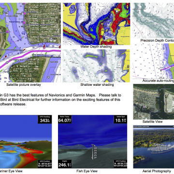
Garmin just released the Australian version of their G3 maps. As an integration of Garmin and Navionics products, the combination provides the outstanding features from both product stables. The accuracy of the charts is unprecedented, combining normal charts with an overlay of satellite imagery for easier interpretation of the environment. Accurate auto-route features make navigating difficult territories easier using all of the accuracy of the finely tuned depth contours.
The depth contours are now at 300mm gradients and can be coupled to Garmin’s Livescope Sonar providing extraordinary clarity and accuracy of underwater features. Relief shading helps identify the water depth for easy interpretation. Another view provides shallow water relief allowing coloured shading of waters too shallow for your craft. 3D views provide clarity of surrounding waters. If you are chasing fish, the G3 maps with Garmin Livescope sonar will give you the edge to ensure you return with the goods. If you take your fishing seriously, please talk to Peter Bird about how Livescope can make your fishing more productive. For navigating challenging waters, the Garmin G3 software coupled with the state of the art Garmin Chart Plotters provides the safety and security that comes from employing the worlds leading navigation system. Act now to take advantage of this new product release!
Please contact Peter at Bird Electrical or call now on 0426 267300 if you want to know more about the outstanding features of this exciting new release from Garmin Australia.


